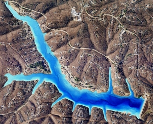
Is GPS Lake Mapping For You?

To fully enjoy your lake or pond it is essential to know the facts. Exact acreage, depths, and chemistry of your lake are critical factors for making the best management decisions. Armed with this knowledge you will be able to properly place structure, deliver appropriate stocking densities, select the correct fish species, apply the right amount of weed control, and of course gain a better idea where those bass may be hiding!
Equipped with the very latest in GPS surface mapping, bathymetry, 3-D contour imaging, aerial and fly-over video resources and virtual underwater swim-view 3-D mapping, we are able to add layers of depth to the information our customers seek. Whether you are tracking sedimentation, planning for dredging, looking to improve your fishery, or simply looking to understand the overall size, volume, and bottom contour of your pond in order to make good management decisions, we have the tools you need to be successful.
The Mapping Network maps lakes throughout the entire year all across the nation. An accurate lake map provides the information needed to make the most of your aquatic resource. The Mapping Network provides the highest quality and is the most affordable bathymetric mapping system on the market today. If you are serious about maintaining a high-quality lake or pond, be sure you have the ability to make the best decisions, get your lake mapped by the professionals at The Mapping Network. Give us a call or send an e-mail to find out more details.
contact: Steve Bartosh
phone: (402) 241-8177
e-mail: [email protected]
website: www.themappingnetwork.com
