Property Owner Association Uses Hydrographic & Sediment Surveys to Create Strategic Sediment Removal Plan – Resulting in Hundreds of Thousands in Savings
The Mapping Network Hydrographic Survey Team exceeds expectations for Property Owner Association.
Overview: A lake property association (POA) has been dealing directly with the challenges associated with sedimentation in their lakes for over 20 years. In 2002 The Board of Directors created a 30 year sediment removal and management plan (2002-2031). They looked at 3 different options: A) hiring a dredging professional, B) leasing dredging equipment and use current POA staff to operate, or C) purchasing a new dredge and using POA staff to operate. They contacted two environmental consultants for cost estimates over the 30 year process. The estimates ranged from $1,000,000 to $5,000,000 which left the POA in a difficult position of trying to make a long term management decision based on wide ranging potential costs. In the end the POA decided to purchase their own dredging equipment an utilize existing staff and volunteers to operated the equipment.
In House Accountability Challenges: After nearly a decade of in house dredging the POA Board of Directors was unable to quantify and verify results. When reviewing the budget requests from the lakes and dam committee, they realized they were spending a lot of resources without having clear information on how successful the sediment removal process had been over the years.
New Vision: The POA decided they needed to quantify the sediment problem to create a sustainable sediment management plan. The president of the board spearheaded an effort to get a hydrographic and sediment survey completed. The president contacted several hydrographic survey companies and chose The Mapping Network to provide this service based on experience in the industry and listening to the needs of the POA.
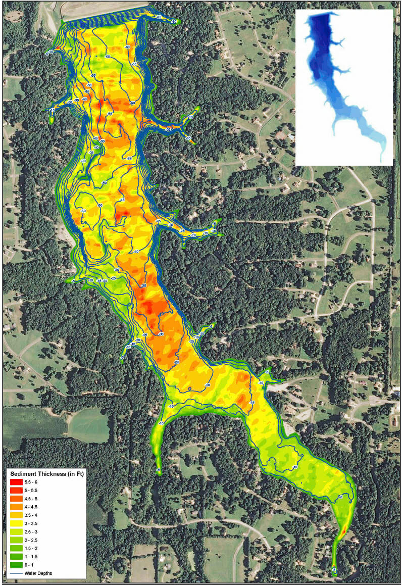
Lake Survey Purpose: The primary objective of the hydrographic and sediment survey was to better understand the condition of the lake by charting the existing lake contours along with mapping the sediment thickness throughout the lake. Once the mapping process was completed the POA was able to identify areas that needed dredging and how much material was there. This allows for much better budgeting and accountability.
Results: The POA was excited to have information based on real numbers (lake and sediment survey). The hydrographic survey results are an essential part of the decision making process with regards to the sediment removal planning. After 20 years of dredging and several studies performed by consultants they felt for the first time they finally understood the problem and how to manage it. Now they have real information, which gives them a clear picture of what to do in the future.
Future: Members of the POA say they will completely change course by finishing up the current in house dredging work and then sell all dredging equipment. They will then work with a professional dredging contractor to clean out specified problem areas identified during the hydrographic survey process. Understanding the true extent of the lake sediment distribution in the lake will save the POA an estimated $200,000 to $300,000 in costs by selling unnecessary equipment and strategic dredging planning. The POA will be using the hydrographic survey information as a baseline for all future work and will adjust the map as dredging continues.
Conclusion: In the end the primary problem facing the POA was not the sediment in the lake but rather not knowing the facts about the lake to make the best decisions. The POA now has the facts needed to create a comprehensive plan that will accurately represent the work being completed. Plus members have a wonderful contour map to assist with fishing!

The Mapping Network is an industry leader in Hydrographic Surveys, Bathymetry, Geographic Information Systems Consulting, Data Conversion, and GPS Data Collection. We specialize in terrain and sub-surface (bathymetry) GPS mapping. If you are serious about maintaining a high-quality golf course, lake or pond, be sure you have the ability to make the best decisions, get your resource mapped by the professionals at The Mapping Network. Give us a call or send an e-mail to find out more details.
phone: (402) 241-8177
e-mail: [email protected]
website: www.themappingnetwork.com
Check out The Mapping Network on Facebook for more examples and success stories!
The Mapping Network is proud to announce their firm has been chosen by Cabela’s, the World’s Foremost Outfitter, as a Landowner Services provider for Cabela’s Trophy Properties throughout the United States. Visit us on the Cabela’s Trophy Properties website >> click here
The Mapping Network: www.TheMappingNetwork.com
A Nationwide Network of GPS Mapping Professionals
