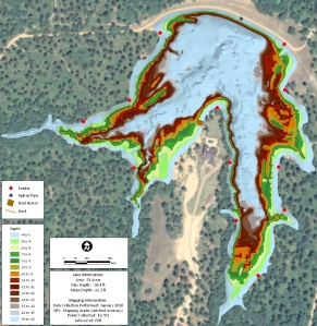
GPS Lake Map Isolates Fishing Hot Spots
Possessing an accurate map of your lake is a great asset to your fishing success. Greg Grimes with Aquatic Environmental Services, Inc., recently completed a GPS lake mapping project for a client in Georgia. This is a master planned lake designed specifically for growing trophy large-mouth bass. Extensive habitat structure, ridges, brush, feeders, etc were carefully placed during construction. Once the lake was full the client had the lake mapped utilizing The Mapping Network’s lake mapping technology to reveal this unseen, underwater world. Combining sub-foot accurate equipment and depth accuracies of up to 1/10th of a foot, the resulting maps provided a picture of the bottom of the lake. Mr. Grimes was able to provide a map highlighting the ideal fishing zones in the range of 4 feet to 16 feet deep at 1 foot intervals. This lake map shows the angler exactly where the fishing hot spots are located on the lake. If you are serious about managing a trophy fishery in your lake contact one of our lake mapping partners to provide the expertise to make it happen!
More information on Aquatic Environmental Services, Inc can be found on their website: http://lakework.com
The Mapping Network: www.TheMappingNetwork.com
A Nationwide Network of GPS Mapping Professionals

