GPS Mapping to Successfully Treat Phragmites
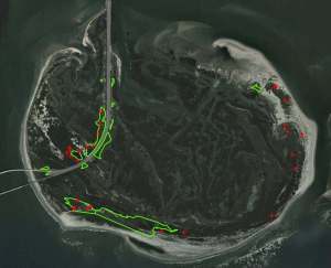
Virginia Lake Management Company is a certified aquatic pesticide applicator in Virginia, Maryland, North Carolina, West Virginia, Delaware, and Pennsylvania, and as such, was contracted by the US Fish and Wildlife Service in a partnership with helicopter applicators to provide the ground application resources required to treat the areas of Phragmites growth that was not able to be treated through aerial applications. As a certified mapping partner of The Mapping Network, Virginia Lake Management used GPS mapping technologies to document and provide detailed maps and aerial photography of the areas in which the Phragmites were treated.
Not only did this allow the customer to quantify the acreage of areas treated and evaluate the costs of the project, it also allowed them to track the progress of the program as compared to previous years. This was the second year that Virginia Lake Management was involved in this project, and progress can already be seen. The density of the Phragmites after the first year’s treatment has been decreased, and much of the natural vegetation has started to recover and return to the areas that were once dominated by Phragmites.
Phragmites is known for its durability and extremely aggressive patterns of growth so this will be an ongoing effort that will likely take many years. However, with the right treatment, and the proper tools and use of GPS technology and aerial imagery, we are able to make great strides towards our goals of eradication of the Phragmites and the restoration of this beautiful natural habitat.
More information on Virginia Lake Management can be found on their website: www.virginialakemanagement.com

The Mapping Network: www.TheMappingNetwork.com
A Nationwide Network of GPS Mapping Professionals
