Preparing for Your Pond’s Future – SOLitude Lake Management
Preparing for Your Pond’s Future by SOLitude Lake Management
As ponds age, their composition changes. Years and years of leaves falling into the pond or sediment from stormwater runoff can drastically change the pond’s bottom. What once was a pond that had an average depth of 5 feet may now be only 3 and in some places there may be less than one foot of depth.
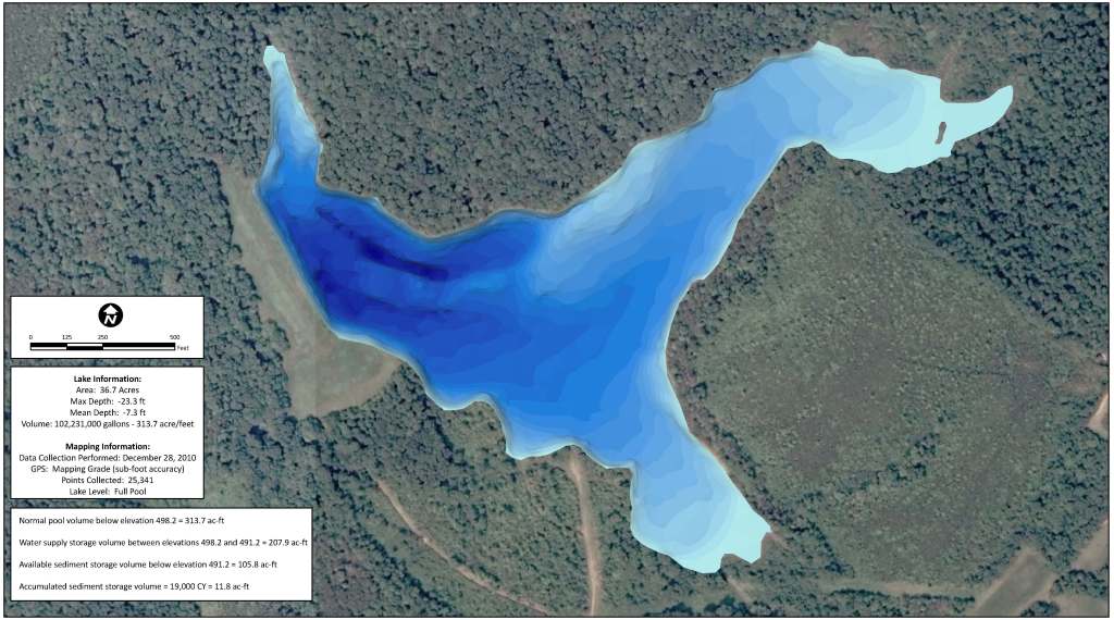
One of the best monitoring tools a pond owner can use is bathymetry. Mapping the bottom of the pond shows areas of concern and can also give you an idea of when dredging may be necessary. With dredging being such a large expense, pond owners can use this tool to help budget for this project in the future.
At this time of the year, when many of you are working with budgets, this tool may be an important one to discuss with your community. Improper planning could leave a community in a situation where a special assessment may be the only solution to cover the expense of a dredging project. Arming your community with this knowledge will prove to have a great impact on the future.
A pond that has filled in with sediment from stormwater runoff or other organic sources will have more problems in the long run with algae and weeds and will become less healthy over time. Knowing the water and sediment depths can give you an understanding of what is happening in your pond and the direction that your pond is heading. We can provide you with excellent 3D maps, seen here, to illustrate just what the bottom of the pond looks like. Contact us today to plan for the future of your pond.
Kevin Tucker is the president of SOLitude Lake Management®, specializing in pond and lake management. SOLitude Lake Management® also controls pond management interests in West Virginia, Pennsylvania, Maryland, Delaware, and North Carolina.
phone: (866) 697-2584
website: http://www.solitudelakemanagement.com

To learn more about our Sediment Mapping here >> Sediment Mapping Detailed
The Mapping Network is an industry leader in Geographic Information Systems Consulting, Data Conversion, and GPS Data Collection. We specialize in terrain and sub-surface (bathymetry) GPS mapping. If you are serious about maintaining a high-quality golf course, lake or pond, be sure you have the ability to make the best decisions, get your resource mapped by the professionals at The Mapping Network. Give us a call or send an e-mail to find out more details.
phone: (402) 241-8177
e-mail: info@themappingnetwork.com
website: www.themappingnetwork.com
Check out The Mapping Network on Facebook for more examples and success stories!
For the best results in mapping, it’s best to consult with a lake management company equipped with the very latest in GPS mapping technology. Along with standard contour maps, The Mapping Network creates virtual media solutions on YouTube including a fly-over video and virtual underwater virtual swim-through. With this knowledge, you can add layers of depth to the information you seek to maintain a beautiful lake.
