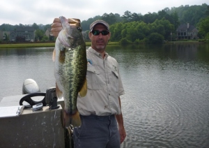
GPS Lake Mapping in Action: Locating Trophy Bass in Georgia
Bathymetric Lake Mapping was performed by Greg Grimes with Aquatic Environmental Services for a homeowners association in a suburb of Atlanta, Georgia. To read more about the mapping project click here. During the mapping process in the field, Mr. Grimes was able to notice the main creek channel. They made sure to collect plenty of data in this area and sure enough the maps showed a defined meandering creek channel.
Mr. Grimes discusses the lake mapping and fish shocking survey process: “When mapping we used our shock boat so knowing this service was part of our management services we performed this service upon completion of mapping. We shocked up many good bass. The real hot spot was the meandering creek. Luckily while mapping we tossed out a few marker buoys. Many large bass floated up right near the markers of the creek channel. One really cool thing that I would also like to share is that we tagged a bass at the boat ramp and 400 yards away it was shocked an hour later in the creek channel. It is amazing in a 32 acre lake to get a bass we just shocked but even more amazing is how far the bass traveled in short time.”
So after the fish survey and mapping for the sedimentation it became clear they also were going to use this map for fishing. During the data processing phase, The Mapping Network provided Aquatic Environmental Services a few GPS coordinates of the hotspots and now the residents can go back and find these locations. Resident Phyllis Lea did just that; she took her granddaughter to the creek channel using the maps and knowledge it provided and had a morning to remember.
While bathymetric mapping might be primarily for monitoring sediment, never underestimate the power it can have for finding fish as well!

The Mapping Network provides the highest quality and is the most affordable bathymetric mapping system on the market today. If you are serious about maintaining a high-quality lake or pond, be sure you have the ability to make the best decisions, get your lake mapped by the professionals at The Mapping Network. Give us a call or send an e-mail to find out more details.
phone: (402) 241-8177
e-mail: info@themappingnetwork.com
website: www.themappingnetwork.com
Aquatic Environmental Services, Inc offers a wide range of lake management and fisheries management services to residential, commercial, and private lake owners throughout Georgia and the southeast. We have been providing these quality services since 1996. AES has the experience and education necessary to provide unsurpassed lake and fishery services. We have selected only the best products available for resale to our customers. Since the year 2000 we have performed services on over 2000 bodies of water.
Aquatic Environmental Services, Inc now has two divisions. Our Lake Management Division (LMD) emphasis is on maximizing the aesthetic appeal of a body of water while our Fishery Management Division (FMD) travels the southeast helping our clients grow big fish. Please visit these pages to find out more specific information on how we can help you with your lake management.
Our staff is comprised of three degreed fishery biologists. Mike Rosa heads LMD and has his B.S. in Fisheries from the University of Georgia. Matthew Morgan is supervisor for FMD and obtained his degree from the famed fishery management program at Auburn University. Greg Grimes, President of AES, obtained his masters in Fisheries from the University of Georgia in 1998 at which time he began the expansion of AES that continues today.
