
Quantifying Sediment in a Lake After a Flood Event
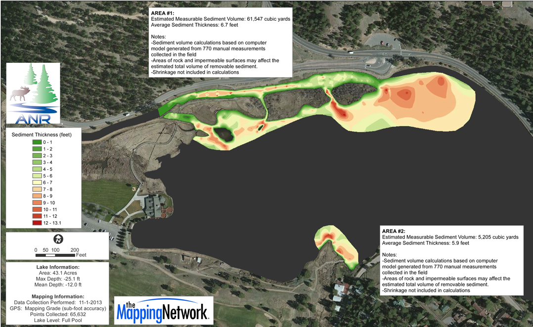
The 2013 Colorado floods were a natural disaster resulting from heavy rain and catastrophic flooding. The impact from this event was a large accumulation of sediment in the areas reservoirs. One of these lakes near Denver had a remarkable amount of soft sediment and rock deposited into the lake. In order to receive funding for removal of this new sediment, the ownership of the lake was required to provide quantitative proof. The Mapping Network used professional GPS and sonar equipment to survey the existing lake bottom and also locate the original lake bottom. Our team generated current lake contour maps, sediment maps and also isolated the main problem areas. 3D models of sediment were created to calculate the amount of material needed to be removed. The end result provided the lake owner the exact information needed to quantify the amount of sediment that needed to be removed and aid in the bid process for removal.
Having an accurate, up-to-date lake survey on file is critical to managing your resource. Not only will it assist in making management decisions but it serves as a baseline for monitoring changes in sediment over time.
#hydrographicsurvey, #sedimentsurvey, #bathymetry, #lakemapping #dredging
The Mapping Network is an industry leader in Geographic Information Systems Consulting, Data Conversion, and GPS Data Collection. We specialize in terrain and sub-surface (bathymetry) GPS mapping. If you are serious about maintaining a high-quality golf course, lake or pond, be sure you have the ability to make the best decisions, get your resource mapped by the professionals at The Mapping Network. Give us a call or send an e-mail to find out more details.
phone: (402) 241-8177
e-mail: info@themappingnetwork.com
website: www.themappingnetwork.com
Check out The Mapping Network on Facebook for more examples and success stories!
![]()
For the best results in mapping, it’s best to consult with a lake management company equipped with the very latest in GPS mapping technology. Along with standard contour maps, The Mapping Network creates virtual media solutions on YouTube including a fly-over video and virtual underwater virtual swim-through. With this knowledge, you can add layers of depth to the information you seek to maintain a beautiful lake.